A lazy start to the day, so after lunch, we make our way back go the town centre. We stock up at a local A101 store and fill Vin with diesel at a shell service station. The D300 takes us the 230 kilometre drive from Gunpinar to Kayseri. For half the journey the road is fine then other half, the asphalt is awful. Paved with walnut sized rocks that jut a half an inch out of the tar and jolt and rattle every bone in your body. At times, it is so bad Vin reverts to a slow crawl.

Road before the bone shaking
An arid looking landscape of stony ploughed fields. First miles upon miles of potatoes with farmers selling huge bags at the road side. Then endless fields of melon with a going rate of 3 for £1! Sadly, the last stretch is covered with blowing rubbish and drifting plastic bags.
Late in the day we come to a city spread dramatically at the bottom the steep sides of jagged limestone mount Erciyes. It’s called Kayseri. As in Istanbul, there is an old and new town. The new town is vibrant, modern with wide roads and shopping complexes. A contrast to the norm of cobbled allies and bazaars. We park next to a modern residential complex in a parking bay. Bazaar as it may sound but it feels delightful. Stepping out in to clean concrete as opposed to dust and rubble is such a pleasure. Mac n Tosh seemed pleased too when walkies included a sniff of green grass as opposed to snorting dust.
Our Bumble wild parking spot at Kayseri GPS position N038.741791, E035.539321

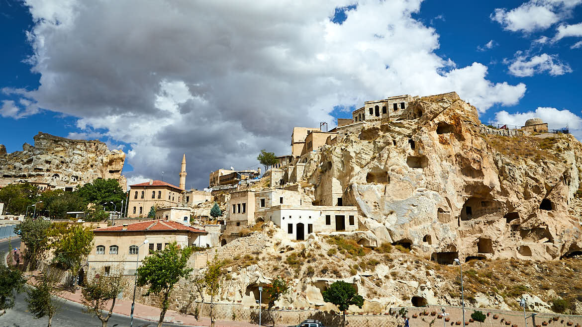
Morning arrives and off we set like giddy teenagers. Once we were out of the city of Kayseri, the traffic was sparse and the roads were well paved. As we drew nearer Cappadocia, we began to notice some of the strange rock formations that make the area world famous. Of all bizarre landscapes created by water, wind and time, Cappadocia is among the strangest.
 Here, bleak desert mesas plunge into canyons studded with spires like giant mushrooms. Cappadocia lies smack in Turkey’s centre, where distances are great and torturous, the land wide, barren and dry, the mountains bald and scorched.


We made our way over to Soganli located in the south of the region. With open countryside, deep canyons and small country villages. Parking options were limited but we managed to park near to the start of the lower valley walk. However, it soon became apparent that this part of Cappadocia is not on many people’s radar. The abandoned dwelling were remote and sadly, in disrepair but the location and setting were rather fetching. Soğanlı’s valleys were first used by the Romans as necropolises and later by the Byzantines for monastic purposes. (click to enlarge photo)


After our walk, we had a cuppa and a bit to eat, whilst we had a read on the area. The formation was pretty interesting stuff…many moons ago, the ash from Mount Erciyes, Hasan and Melendiz volcanoes settled in the valley. Over the years, the ash compacted to form rock. Continued eruptions deposited layers of lava on top, which became basalt. As the basalt was harder than the compacted ash, erosion occurred unequally, sculpting fantastic spires and needles. The Turkish people say that man could not have built them and God was too busy, so they must have been created by fairies hence their name – fairy chimneys.

Soğanlı parking spot
Soğanlı was like a powder village covered in fine, minute dust. Every time a vehicle went passed (mainly tractors) we got covered in dust. It really wasn’t pleasant, so we moved on to our next port of call Mustafapasa. A brilliant little village with excellent parking location, right on top of the village pinnacle!

Our Bumble wild parking spot at Mustafapasa GPS position N038.583119, E034.899114


Not a bad view from up here
Discover more from Our Bumble
Subscribe to get the latest posts sent to your email.
This is só beautifull ! Normal tourist doesn’t see this. Is it ok when I share your photos with friends?
Of course Joke x
That is definately my kind of adventure. I went to Cappadocia many years ago and vpnever even realised thus was around the corner. Tour guide take away your ability to think for yourself.
You sound like Craig…tour guides are brilliant as long as you interact.
Wow. Gorgeous. Our parents went earlier in the year. Are you finding it easy to find places to stay overnight. Would love to go one day. Thanks and enjoy the rest of Turkey!
Its a wild camper paradise. So easy to find places to sleep
Can I ask how many hours in total have you spend on the road this trip? We did a trip in France and were on the road for about 30 hours in total in around 6 days…and can’t even remember where we visited lol. Think we need to get a better balance.
You can ask Liam but truth is we have not got a clue. If our bum goes numb then we know its time for a coffee break lol
This is the reason why I travel guys. Finding hidden gems is as fun as seeing world famous tourist spots, beaches, city centers or any of that stuff. Sure I love a gorgeous beach. But stumbling upon a place off the beaten path like this joint before the tourist hotspots makes circling the globe so worth it. Excellent post.
Us too, hidden gems always leave a warm feeling in your hearts.
I’ve been following your posts – as I always do – absolutely blown away by your pics and blogs on this trip. I’ve got 3 months or so next spring and would absolutely LOVE to get to some of these places 🙂
Good luck Jennifer, I feel a good plan in the making x
Fantastic as always Joanne. Feels like we are travelling with you. I look forward each morning to the next post, like turning the page to the next chapter
Cheers Lesley…a few more weeks and we’ll be tapping on your door for a cuppa!